[302]
CHAPTER XIX.
RECAPITULATION
OF THE GENERAL ARRANGEMENT OF THE STRATIFIED FORMATIONS OF
ENGLAND.
THE geology of England and Wales is much more comprehensive than that
of Scotland, in so far
that it contains many more formations, and its features therefore are
more various. England is
the very Paradise of geologists, for it may be said to be in itself an
epitome of the geology of
almost the whole of Europe, and much of Asia and America. Very few
European geological
formations are altogether absent in England. On the Continent, however,
some have a larger
importance than in England, being more truly oceanic deposits in some
cases, and more
thoroughly developed lacustrine or terrestrial deposits in others. In
some countries larger than
England the whole surface is occupied by one or two formations, but in
England nearly all the
formations shown in the column (p. 30) are more or less developed.
Those of Silurian age lie
chiefly in England, in Cumberland and Westmoreland, and in the west, in
Wales (fig. 57, p.
304). Above them lie the Old Red Sandstone and Devonian rocks,
occupying large areas in
Herefordshire, Worcestershire, South Wales, and in Devonshire and
Cornwall. Above the Old
Red Sandstone come the Carboniferous strata, which form large tracts of
Devonshire, Somerset, and part of Gloucestershire,
[English Formalions. 303]
and in South Wales skirt the Bristol Channel, and stretch into the
interior in Pembrokeshire,
Glamorganshire, and Monmouthshire; while in the north they border North
Wales, and form a
broad backbone of country that reaches from the borders of Scotland
down to North
Staffordshire and Derbyshire. Other patches, here and there, rise from
below the Secondary
strata into the heart of England. (See Map.)
The general physical structure of England, from the coast of Wales to
the Thames, will be easily
understood by a reference to fig. 57, p. 304, and to the following
descriptions; and this
structure is eminently typical, explaining, as it does, the physical
geology of the greater part of
England south of the Staffordshire and Derbyshire hills.
The Lower
Silurian rocks of
Wales (No. 1) consist chiefly of slaty and solid gritty strata,
accompanied
by, and interbedded with, numerous feispathic lavas and beds of
volcanic
ashes, marked + ; and mingled with these there are numerous bosses and
dykes
of felstone, quartz-porphyry, greenstone (diorite), and the like. These
last,
by their superior hardness, give a mountainous character to the whole
of
North Wales, from Merionethshire to the Menai Straits. In part of north
Pembrokeshire
also, in a less degree, igneous rocks are largely intermingled with the
Lower
Silurian strata, and these, by help of denudation, now form a very
hilly
country.
Without again entering into details, it is here sufficient to state
that the Cambrian arid Lower
Silurian epoch was ended in the British area by disturbance and
contortion of the strata, and
their upheaval into land. This disturbance necessarily gave rise to
long-continued denudations
of this early English land, both by ordinary
[303]
FIG.
57
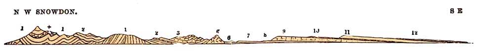
Diagrammatic Section from the Menai Straits across Wales, the Malvern
Hills, and the
Escarpments of the Oolitic Rocks and the Chalk See Map, line 6.
Nos. 1 to
3, 5, and g represent the disturbed Cambrian, Lower and Upper Silurian,
and Old
Red Sandstone mountainous country of North Wales, the adjacent
countries on the east, and the
Malvern Hills g.
6 to 8 the plains and slightly undulating grounds of the New Red
Sandstone, Red Marl, and Lias.
9 and 10 the great Oolitic escarpment of the Cotswold Hills, forming
the first tableland.
11 the great escarpment of the Chalk, forming a second tableland, above
which lie the Eocene
strata, 12.
The Upper Oolites, close below the Chalk escarpment 11, are in places
of less height relatively to
the sea than the edge of the Oolitic escarpment at 9.
[English Formations. 305]
atmospheric agencies, and also by the action of the waves of the sea of
a younger Silurian period,
the evidence of which is seen in the conglomerates of the Upper
Llandovery beds, which,
mingled with marine shells, lie unconformably on the denuded edges of
the Cambrian and Lower
Silurian strata of the Longmynd in Shropshire, like a consolidated sea
beach. Slow submergence
then took place beneath the Upper Silurian sea, in which the Upper
Silurian rocks were
gradually accumulated unconforinably till, perhaps, they entirely
buried the Lower Silurian
strata (2, fig. 57), for in places they attained a thickness of from
three to six thousand feet.
As shown in Chapter VIII. the uppermost Upper Silurian beds of Wales
pass insensibly into a
newer series, known as the Old Red Sandstone (3, fig. 57), formed, if
we include the entire
formation, of beds of red marl, sandstone, and conglomerate, which in
all the British areas by
the absence of marine shells, and the occasional presence of
crocodilians, land reptiles, and of
fish (whose nearest allies live in the rivers and lakes of America and
Africa, or in the brackish
pools of Australia), seem to have been deposited in lakes. In Wales,
these strata again pass
upwards into the Carboniferous Limestone, which is overlaid in Wales,
Derbyshire, and,
Lancashire, by the Millstone Grit and the Coalmeasures.1
In Yorkshire, Durham, Northumberland, and Scotland, the Carboniferous
Limestone has no
pretension to be ranked as a special formation, for it is broken up
into a number of bands
interstratified with masses of
1 This is not shown in
fig. 57, but the Carboniferous Limestone No. 4 is shown in fig. 67, p.
330, lying, as it does in North Wales, unconformably on Silurian rocks.
[306 English Formations.]
shales and sandstones bearing coals. In fact, viewed as a whole, the
Carboniferous series
consists only of one great formation, possessing different lithological
characters in different
areas, these having been ruled by circumstances dependent on whether
the strata were formed
in deep, clear, open seas, or near land; or actually, as in the case of
the vegetable matter that
forms the coals, on the land itself.
The English Carboniferous rocks differ from the Scottish beds in this,
that in general they have
not been mixed with igneous matter, except in Northumberland and
Derbyshire, where, in the
last-named county, the Carboniferous Limestone is interbedded with
ashes and lava, locally in
Derbyshire called 'toadstones.' In South Staffordshire, Colebrook Dale,
the Clee Hills, and
Warwickshire, there is a little basalt and greenstone, which may
possibly be of Permian age,
intruded into, and perhaps also partly overflowing, the Carboniferous
rocks in Permian times;
but in Glamorganshire, Monmouthshire, North Staffordshire, Lancashire,
and Yorkshire, where
the Coal-measures are thickest, no igneous rock of any kind occurs.
There and elsewhere in
England the Coal-measures as usual consist of alternations of
sandstone, shale, coal, and
ironstone.
Next in the series come the Permian rocks (2, 3, 4,
fig. 30, p. 141), which, however, rarely occupy so great a space in
England, as materially to
affect the larger features of the scenery of the country. They form a
narrow and marked strip on
the east of the Coalmeasures from Northumberland to Nottinghamshire,
where they chiefly consist of a long, low, flat-topped terrace of
Magnesian limestone (see
Map), interstratified
[English Formations. 307]
with two or three thin beds of red marl sometimes containing gypsum.
The scarped edge of this
limestone, which is sparsely fossiliferous, faces west, and overlooks
the lower undulations of
the Coal-measure area.
There are
other patches of
Permian sandstones, mans, breccias, and conglomerates, in the South of
Scotland,
the Vale of Eden, and the West of Cumberland, and they are also here
and
there present on the borders of the Lancashire, North Wales,
Shropshire,
and all the Midland coal-fields, and on the Silurian rocks o the
Abberley
and Malvern Hills. Throughout all the districts enumerated above, these
Permian
strata chiefly consist of red sandstones, conglomerates, and mans, and
part
of them, in the districts of the Malvern and Abberley Hills, near
Enville,
and at Bromsgrove, consist of consolidated true Permian glacial
boulder-clays.
The Permian beds form the uppermost members of the so-called
Palæzoic or old-life period—a
term somewhat unphilosophical, in so far that it partly conveys a false
impression of a life
essentially distinct from that of later times. But it is at present
convenient, for all geologists
know when the word palozoic is used what formations are meant,
embracing all the strata from
those of Permian date down to the lower Laurentian. During the time
they were forming, this
and other parts of the world suffered many oscillations of level,
accompanied by denudations, as
shown in previous chapters.
Before the end of this Palaeozoic epoch, the Permian beds were
deposited in great inland salt
lakes, analogous to the Caspian Sea and other salt lakes in Central
Asia, at the present day. That
area gives the best modern idea of the state of much of the world
during Permian times.
[308 English Formations.]
In the same continental area, and partly on the Permian rocks, partly
on older subjacent strata,
the New Red Sandstone and Marl of our region were then deposited in
lakes perhaps occasionally
fresh, but as regards the marl certainly salt. These formations fill
the Vale of Clwyd in North
Wales, and in the centre of England range from the mouth of the Mersey
round the borders of
Wales to the estuary of the Severn, eastwards into Warwickshire, and
thence northwards into
Yorkshire, along the eastern border of the Magnesian limestone (see
Map). They are absent in
Scotland. In the centre of England the unequal hardness of its
subdivisions sometimes gives rise
to minor escarpments (Nos. 4 and 6, fig. 32, p. 154), most of them
looking west over plains
and undulating ground formed of soft red sandstone. Such escarpments
are especially
remarkable in the case of the Keuper sandstone, which lies at the base
of the New Red Marl.
These strata
frequently form a good building stone, often white, and because of
their hardness having better
resisted denudation than the red sandstones below, they stand out as
bold cliffy scarps facing
west, with long gentle slopes to the east. Such are Hilsby lull, that
looks out upon the Mersey,
near Frodsham; the beautiful terraced scarps of Delamere Forest, the
grand castle-crowned cliff
of Beeston by the North Western Railway, near Tarporley, and the
beautiful heights, often well
wooded, that stretch from thence to the south, and form the Peckforton
Hills. There, among spots
that haunt
the memory, in the ancient park of Carden, scarped by nature and cut
into terraced walks and
caverns,
among the red and white cliffs grow great rhododendrons, which sow
themselves in every mossy
cleft of the rocks; luxuriant brackens, male ferns, lady ferns,
[English Formations. 309]
Lastræas, and others of smaller growth, while all forest trees
attain a goodly growth, and low
down in the flat, deer are grazing up to the gates of the old
broadfronted timbered Hall. It is
indeed a splendid sight to stand on the edges of these scarped hills
and look across the great
rolling plains of New Red Sandstone below, bounded by Moel Famau and
all the mountains of
North Wales that surround the beautiful Vale of Clwyd; or twenty miles
further south, from the
abrupt cliff of Grinshill, to see the tall spires of Shrewsbury backed
by the renowned Caer
Caradoc, the Wrekin, the high line of the flat-topped Lougmynd, and the
craggy Stiper Stones.
The New Red Marl passes insensibly into the Rhætic beds, which
again pass insensibly into the
Lower Lias. In England there is therefore a gradation between the New
Red Marl and the Lower
Lias.
The Lias series, Nos. 3, 4, 5, fig. 5, consists of three belts of
strata, running from Lyme Regis
on the south-west, through the whole of England, to Yorkshire on the
north-east: viz. the Lower
Lias clay and Limestone, the Middle Lias or Marlstone strata, and the
Upper Lias clay. The
unequal hardness of the clays and limestones of the Liassic strata
causes some of its members to
stand out in distinct minor escarpments, often facing west and
north-west. The Marlstone No. 4,
forms the most prominent of these, and overlooks the broad meadow-land
of Lower Lias clay
that form much of the centre of England.
Conformable to and resting upon the Lias are the
various members of the Oolitic series (6 to 11, fig. 5).1
That portion termed the Inferior Oolite occupies the base, being
succeeded by the Great or Bath
Oolite,
1 See also the 'Column
of Formations,' p. 30.
[310 English Formations.]
Cornbrash, Oxford Clay, Coral Rag, Kimeridge Clay, and Portland beds.
These, and the
underlying formations, down to the base of the New Red Sandstone,
constitute what geologists
term the Older Mesozoic or Secondary formations, and all of them, from
their approximate
conformability one to the other, occupy a set of belts of variable
breadth, extending from Devon
and Dorsetshire northwards, through Somersetshire, Gloucestershire, and
Leicestershire, to
the north of Yorkshire, where they disappear beneath the German Ocean.
FIG.
58.
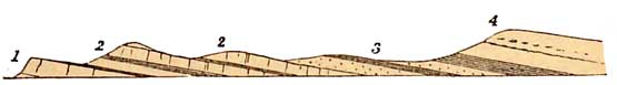
1. Portland
Oolite.
2. Purbeck Limestones
and Marls.
3. Wealden Sands and
Clays.
4.
Cretaceous
strata.
When the Portland beds had been deposited (see figs. 39 and 58), the
entire Oolitic series, in
what is now the south and centre of England, and much more besides in
other regions, was raised
above the sea-level and became land. Because of this elevation, there
is evidence in the Isles of
Purbeck, Portland, and the Isle of Wight, and in the district known as
the Weald, of a state of
affairs which must have been common in all times of the world's
history. We have there a series
of beds, consisting of clays, loose sands, sandstones, and shelly
limestone, indicating, by their
fossils, that they were accumulated as a delta and in lagoons in an
estuary, where fresh water
and occasionally brackish water and marine conditions prevailed at the
mouth of a great
continental river. The position of these beds, with respect to the
Cretaceous strata, will be seen
in
[English Formations. 311]
fig. 72, p. 339, marked w, h, proving that they are
intermediate in date to the Oolites and
Cretaceous rocks, for in the Isle of Purbeck, near Swanage, they are
seen lying between the two
(fig. 75, p. 348).
This episode at last came to an end, by the complete submergence of the
Wealden area, and of the
greater part of England besides; and upon these fresh-water strata, and
the Oolitic and other
formations that partly formed their margins, a set of marine sands and
clays were deposited in
the south of England, consisting of the Atherfield Clay and the Lower
Greensand s, d (fig. 72, p.
339) is now often classed with the Upper Neocomian beds of the
Continent, but in England they
have till lately generally been known as the Lower Cretaceous strata.
The distinction is not
important to my present purpose. Then comes the clay of the Gault,
above which lies the Upper
Greensand. Resting upon the Upper Greensand comes the Chalk (No. ii,
fig. 57, and c. fig. 72),
the upper portion of which contains numerous bands of interstratified
flints, which originally
were partly marine sponges, since silicified. The Chalk, where
thickest, is from one thousand to
twelve hundred feet in thickness. The Liassic and Oolitic formations
were sediments spread in
warm seas sirrounding an archipelago of which Dartmoor, Wales,
Cumberland, and the
Highlands of Scotland formed some of the islands. But the Chalk was a
deep sea deposit, formed to
a great extent of microscopic foraminifer, and while it was forming in
the wide ocean, it seems
probable that the old islands of the Oolitic seas subsided so
completely, that it is doubtful
whether or not even Wales and the other older mountains of Britain were
almost entirely
submerged.
During the period that the Oolitic formations formed
[312 English Formations.]
part of the land through which the river flowed that deposited the
Wealden and Purbeck beds,
they were undergoing constant waste, so that in the course of time,
having been previously
tilted upwards to the west with an eastern dip (fig. 59), they were
worn into what I. have
elsewhere termed a plain of marine denudation (see p. 497). The
submergence of the Wealden
area was followed by the progressive sinking of the Oolitic and older
strata further west, so
that, as the successive members of the Cretaceous formations were
deposited, it happened that
by slow sinking of the land, the Upper Cretaceous strata gradually
overlapped the edges of the
outcropping Oolitic and Liassic formations, till at length they were
intruded on the New Red
series, and even on the Palæozoic strata of Devonshire itse1f, as
shown in fig. 59.
The upheaval of the Chalk into land brought this epoch to an end, and
those conditions that
contributed to its formation ceased in our area. As the uppermost
member of the Upper
Secondary rocks, it closes the record of Mesozoic times in England.
This brings us to the last divisions of the British strata which I
shall now name. These were
deposited on the Chalk, and are termed Eocene formations (No. 12, fig.
57, p. 304). At the base
they consist of marine and estuary deposits, known as the Thanet Sand,
and Woolwich and
Reading beds, and which are of comparatively small thickness, say from
50 to 150 feet. These
lie below the London Clay and form the outer border of the London
basin. The Woolwich and
Reading beds are found in the Isle of Wight, and in part constitute the
Hampshire and London
basins. In these we have in places the same kind of alternations of
fresh
[313 English Formations.]
FIG.
59
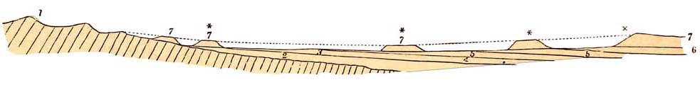 Overlap of the
Oolitic and other Strata by Cretaceous Formations.
Overlap of the
Oolitic and other Strata by Cretaceous Formations.
1.
Represents the Paleozoic strata. 2. The New Red beds. 3. The Lias. 4,
5, 6. Various members
of the Oolites, and 7. The upper Cretaceous strata. The dotted line
represents the original
continuation of the Chalk westward, the slope marked x the present
escarpment of the Chalk, and
the hills marked with asterisks (*) outlying patches of the same, the
relics left by old
denudations, and which help to prove the original far westward
extension of the Upper Cretaceous
strata.
[314 English Formations.]
water and marine shells that I mentioned as occurring in the Wealden
and Purbeck strata; but
with this difference, that though the shells belong mostly to the same
genera, they are of
different species—the old freshwater life is replaced by new.
Upon the London Clay, which is a marine formation, varying from 200 to
500 feet thick, the
Bracklesham and Bagshot beds were deposited. These consist of marine
unconsolidated sands and
clays, occurring as outliers—isolated patches left by denudation around
Bagshot, and elsewhere
on the London Clay, and overlying the same formation in the Isle of
Wight, where they are well
seen in Alum Bay. In both these places they are only sparingly
fossiliferous, but at Bracklesham
and Barton, on the Hampshire coast, they contain a rich marine
molluscan fauna of a tropical or
subtropical character. Upon these were formed various newer fresh-water
strata, occasionally
interbedded with thin marine bands, the whole evidently accumulated at
the mouth of a river.
For the names of these minor formations, I refer the reader to the
column, p. 30.
I have in this chapter given a brief recapitulation of the geological
and stratigraphical positions
of the series of the larger and more solid geological formations that
are concerned in producing
the physical structure of England (see Map), and I will in the
following chapters endeavour to
show by the help of fig. 57, and other diagrams, the part that these
formations play in
producing the scenery of the country.