CHAPTER XXIII.
THE GLACIAL EPOC1T.—EXISTING GLACIER REGIONS.
I HAVE now to describe a remarkable episode in PostTertiary times, known as the Glacial epoch,
which is certainly later than the latest beds of the Crag, and is generally considered to be of
later date than the 'Forest bed' of Cromer, on sound stratigraphical evidence. The effect of local
mountain glaciers, and
of far broader sheets of glacier ice that descended from the mountains and overspread great
plains, have left unmistakable traces over large parts of the northern and southern
hemispheres; and without going into all the minutiae of the subject I shall be able to describe
the history of that period, as it affects the scenery of Britain, with something like detail. Before
doing so, however, I must lead the reader into Switzerland, and show what kind of effect is being
produced there by the ice of the present day, and afterwards into Greenland and Victoria Land,
and show what takes place there, and then by the knowledge thus gained 1 shall be able to return
to our own country and explain what took place here in that icy episode, which, measured by
ordinary standards, is far distant in time, but which, by comparison with the more ancient
periods, almost approaches our own day.
The first thing to be done is to explain what a glacier is. In any large and good map of Switzerland
[362 Glaciers.]
we see certain white patches
here and there on the higher mountain ranges of the Alps. These are more
or less covered by snow and glaciers. The highest mountain in the Alps, Mont
Blanc, rises more than 15,000 feet above the sea, and there are many other
mountains in this great chain which approach that height, ranging from 10,000
to 15,000 feet high. The mean limit of perpetual snow upon the Alps, is about
8,500 feet above the level of the sea. Above that line, speaking generally,
the country is to a great extent covered with snow, excepting where the tall
cliffs are too steep to hold it, or on those sides of even high valleys that
face the southern sun. In the higher regions it gathers on the mountain slopes,
and in the large cirques or recesses, which like vast amphitheatres, are
characteristic of all true mountain groups or ranges that I have seen. By
force of gravity, and the alternate melting and regelation of the molecules
of ice, especially in summer, the gathered snow presses downwards into the
main valleys; where, chiefly in consequence of the immense pressure exerted
by the vertical weight and onward pressure of the accumulated mass, the snow
year after year is converted into moving ice. Without entering on details,
it is enough if I now state that this is proved by well-considered observations
made by the best observers of the icy phenomena of the Alps.1
Still accumulating, year upon year, by degrees this ice slides down the valley, and is often
protruded in great tongues far below the limits of perpetual snow; for some Swiss glaciers
descend as low as from three to four thousand feet or thereabouts above the level of
1
See Dr. James Croll's work on, Climate and Time.'
[Glaciers. 363]
the sea, whereas the limit of perpetual snow is 8,500 feet. Ever melting on its surface, in its
mass, and at the end, each glacier is yet ever renewed by yearly falls of snow, and by direct
gravity on the slopes, and by pressure of accumulating snow and ice behind, and by melting and
regelation, it is urged down the valley and maintains its average size. I will not enter into all
the details of the structure of the ice of glaciers, because that will not help us in the special
geological investigation now in view; but I will describe what are the effects produced by a
glacier in the country
over which it slides, and various other glacier-phenomena affecting the scenery of the Alps,
and therefore affecting the scenery of our own country in past times when glaciers existed here,
and still affecting it in the relics they have left.
A glacier slides more or less rapidly according to the mass of ice that fills the valley, and to the
greater or less inclination of the slope, for in these respects it behaves very like a river. If we
have a vast river like the Mississippi flowing down a broad valley, although the slope of the
valley may be gentle, still the river flows with rapidity, in consequence of the greatness of the
body of water; so if we have a mass of ice, which represents the snow-drainage of a large tract
of country, covered with perpetual snow, then the glacier flows with a rapidity proportionate to
the mass of ice, and that rate of progress is modified, increased, or diminished, in accordance
with the fall and width of the valley, so that when it is steep, the glacier flows comparatively
fast, and when the angle at which the valley slopes is small, it flows with comparative slowness.
Like a river also when the valley expands in width, so does the glacier broaden to meet the
mountain sides on
[364 Glaciers.]
either hand, and should an extra steep descent occur in its channel, as in the glacier of the
Rhone, the ice becomes troubled and shattered, like a silent frozen cataract, to re-unite below
in a more tranquil sheet. So also in the valley of Hinter Rhine, above the source of the river, a
tall cliff bounds the eastern side of the Rhine glacier, above which another large ice-sheet
presses to the edge of the precipice, from whence in summer, constant avalanches, now here,
now there, fall with a sheer descent and a recurrent roar like that of a great waterfall.
All glaciers are traversed by cracks termed crevasses.
Now the mountain peaks that rise above the surface of a glacier are in places so steep that the
snow refuses to lie upon them, even when they may happen to be above the limits of the average
line of perpetual snow, so that masses of rock being severed by atmospheric disintegration,
constantly fall from the slopes and find a temporary resting-place on the surface of the ice at
the margin of the moving glacier, and, as it were, float upon its surface in long continuous
lines; for the motion of a glacier is so slow, that the stones that fall upon its surface are
sufficiently numerous to keep up a continuous line of blocks, earth, and gravel, often of great
width. In like manner if an island-like boss of rock rises through the ice in the middle of a
glacier, a line of stony debris travels on the surface of the glacier from the lower end of the
island, which, often buried in the winter's snow, becomes again exposed during the heat of
summer. These stones, when two glaciers combine to form one stream of ice, as in the lower
glacier of the Aar, meet at the V-shaped angle of junction, and form one grand line running down
the centre of the glacier (fig. 78). Such lines of débris,
[Glaciers. 365]
whether at the sides or in the middle of a glacier, are termed moraines, and at length all this
material that has not fallen into crevasses floats on, and is finally slowly shot into the valley at
the end of the ice-stream, frequently forming large mounds, known as terminal moraines.
All glacier ice, even in the depth of winter in Arctic regions, is said to be at a temperature of
about 32° Fahr. that is to say, just about the melting point, excepting near the surface, as far as
the cold atmospheric temperature can penetrate. This, it is said, is rarely more than eight or
ten feet. Therefore, it is a common statement that, beneath every glacier, water is constantly
flowing, caused by the melting of the ice below all the year round, and also by the summer heat
on the surface of the glacier, and in some cases, to a less degree, by springs that rise in the
rocks below the ice.1 In parts of some glaciers where crevasses are not numerous, we frequently
find large temporary brooks, which generally disappear with the frost at night; but in all the
glaciers that I have seen, long before we reach their lower end, all the surface water has found
its way to the bottom of the ice.
The water that runs from the
end of a glacier very often emerges from an ice-cavern as a ready-made muddy
river, charged with the flour of rocks, produced in great part by the grinding
power of the glacier moving over its rocky floor, and this river carries
away the moraine
1
I am, however, informed by Mr. James Eccles that in the midwinter of 1875 when he was in the
Valley of Chamouni no water flowed from the end of the well-known Glacier de Bossons, and that
at the lower end of the large glacier of the Mer de Glace (Glacier des Bois) the stream which is
large in summer had decreased to a tiny rivulet. The subject requires more systematic
investigation both in the Alps and Greenland.
[366 Glaciers.]
rubbish that the glacier deposits at its lower ends, in some cases almost as fast as it is formed,
perhaps, I might rather say, as slowly as it is formed, because day after day we may see
scarcely any difference in the details of certain moraines, though, when being worked upon by
water, all stones of moderate size that have been shed from the ice are in the long run apt to be
carried down the valley by the ever-changing streams that flow from the ends of glaciers along
the length of many terminal moraines. In some cases, however, it happens that, from various
circumstances, both terminal and lateral moraines have been so well preserved from
destruction, that they form long enduring features in the scenery.
Something remains to be said about moraine-stones before I describe the glacial phenomena of
our own island. When an immense weight of glacier ice, in some cases hundreds, or in Arctic and
Antarctic regions even two or three thousand feet in thickness, passes over solid rocks, by the
pressure of the moving mass, the rocks in the valley over which it slides become smooth and
polished-not flatly, but in flowing lines, presenting a largely, mammillated surface.
Furthermore, the stones of the surface-moraines frequently fall into fractures called
crevasses, and the small debris and finely powdered rocks that more or less cover the glacier
are borne into these crevasses by the water that flows upon the surface, and much of this matter
finds its way to the bottom of the ice, fig. 78. The bottom of a glacier, therefore, is not simple
bare ice, but between the ice and the rock over which it flows there are blocks of stone
imprisoned, and fine silicious and often felspathic débris (chiefly worn from the floor itself),
which may be likened to emery powder. The
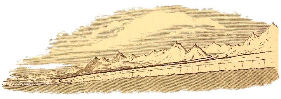
Imaginary section of a swiss Glacier.
Showing Moraines, crevasses, and the undulating form of the ground underneath (small Roches Moutonnées).
[368 Glaciers.]
result is that, let the rock be ever so hard, it is in places polished almost as smooth as a
polished agate, and this surface is also finely striated and coarsely grooved by the debris that,
imprisoned between the ice and the rocky floor, is pressed along in the direction of the flow of
the ice. By degrees deep furrows are sometimes thus cut in the rocks.
But the stones that are imprisoned between the ice and the rocky floor not only groove that
floor, but in turn they also get scratched by the harder asperities of the rocks over which they
are forced; and thus it happens that many of the stones of moraines are covered with straight
scratches, often crossing each other irregularly, so that we are able by this means to tell,
independently of the forms of the heaps, whether such and such a mass is a moraine or not, and
indeed, under any circumstances, whether certain stones have been acted on by glacier ice.
These indications of the rounding, smoothing, scratching, and grooving of rocks, in lines
coincident with the direction of the flow of glaciers, together with moraine heaps, erratic
blocks, and scratched stones, are so characteristic of glaciers, that we are able to establish the
important fact that the Swiss glaciers were once of far larger dimensions than they are now, and
have gradually retreated to their present limits. For example, all down the Valley of the Rhone,
from the end of the Rhone glacier to the Lake of Geneva, mammillated rocks (moutonnée),
moraine-mounds, and great erratic blocks, are of frequent occurrence, a notable case occuriing
on the slopes behind Monthey, some sixty miles below the source of the river, where the 'blocks
of Monthey' have long been celebrated. Fifty miles beyond that, the same great glacier that filled
the
[Ancient Alpine Glaciers. 369]
valley of the Rhone, spread across the area, now filled by the Lake of Geneva and all the lowlands
of Switzerland, in a vast fan-like form, a hundred and twentyfive miles in width from below
Geneva to the neighbourhood of Aarau, and deposited part of its terminal moraine on the slopes of
the Jura behind Neuchâtel, 2,200 feet above the level of the lake. The famous Pierre a Bot, 50
feet long by 20 feet wide, and 40 feet in height, forms one of a belt of moraine blocks at a
height of about 800 feet above the level of the lake of Neuchâtel. Every Alpine valley, whether
in the heart of the mountains, or on the northern slopes opening into the lowlands of
Switzerland, or on the wide plains of Italy that lie between the Alps and the Po, tells the same
story; and the old glacier of the Dora Baltea, about a hundred miles in length, which from Mont
Blanc to beyond Ivrea filled the whole valley of Aosta, has left on the plains of Italy a vast
moraine 60 miles in circumference, more than 1,600 feet in height, and in places 6 or 7 miles
in width. The signs of vanished gigantic glaciers constantly strike the practised eye, and are
indeed frequently as fresh as if the glacier had scarcely left the rocks before the existing
vegetation began to grow upon their surfaces.
Such being the case in the Alps and other regions where we are able to study the action of
modern glaciers in detail, we have next to inquire—Is there anything further to learn in regions
where glaciers are found on a far greater scale? Those who have read the descriptions of
navigators will be aware that in Greenland the average snow-line, as a whole, descends lower
and lower as we go northward, till at length the whole interior of the country becomes covered
by one snowfield, which, pressing seaward from the interior, gives
[370 Modern Large Glaciers.]
birth to a prodigious number of large glaciers, many of which protrude far into the Fjords,
while very many others on a smaller scale descend directly into the sea from the mountains on
either side. In other cases, as on straight parts of the coast of Melville Bay, the glacier-ice
crowns the cliffs for miles, and breaking off in masses, falls in cataracts of small-shivered
icebergs into the sea, grinding and smoothing the rock as they descend. But in the same region
when broad valleys open out towards the sea, then it frequently happens that prodigious glaciers
push their way out far beyond the shore. These are in some cases 12 or 20 miles across at their
ends, and in the case of the great Humboldt glacier, 60 miles across, ending in a cliff of ice in
places 300 feet in height. One of these vast glaciers has been estimated as being at the very least
3,000 feet in thickness. Great masses of ice breaking away from their ends form icebergs,
which, sometimes laden with moraine rubbish, like that which partly covers the glaciers of
Switzerland, float out into the Greenland seas, and are carried south by a current in Baffin's
Bay. Not infrequently icebergs float far into the Atlantic, beyond the parallel of New York, and
they have been seen even off the Azores.
Along the shores also, when the sea freezes, the ice becomes attached to the coast. By-and-by, as
summer comes on, the ice partly breaks away, leaving what is called an ice-foot still joined to
the land. Vast quantities of debris during part of the year fall from the cliffs, and are lodged
upon the ice-foot, and when it breaks off and floats away and melts, the rubbish is strewn
about, and accumulates on the bottom of Baffin's Bay. In like manner the icebergs melt chiefly
in Baffin's Bay, but sometimes escaping from thence and melting
[Modern Large Glaciers. 371]
in the seas of warmer climates, their stony freights, when they have any, get scattered abroad
here and there over the bottom of the West Atlantic, which, therefore, must be dotted with
erratic blocks and other debris borne from far northern regions.
The same kind of phenomena, on a still grander scale, are common in the Antarctic regions of
Victoria Land. There, between south latitude, 71° and 79°, the land, as described by Sir James
Ross, rises in places to 10,000, and even 15,000 feet in height, and the whole country may
almost be said to be covered by a universal sheet of glacier ice, which, protruding far seaward,
rises in cliffs from 150 to 250 feet above the level of the sea. Such a wall, east of Mount
Erebus, extended in 1841 for a distance of about 600 miles, and from it and parts of the coast
great tabular bergs break off, occasionally bearing blocks of volcanic rocks. Sir James
estimated the average thickness of the glacier ice to be not more than 1,008 feet, but in many
cases this is doubtless an under-estimate. This Antarctic continent is probably as large as or
larger than Australia, and every yard of its surface must be ground and polished by the nearly
universal glacier that radiates from its centre to the sea.
Having ascertained what are the signs by which a glacier may be known, and also the signs left
by icebergs, I shall now show that a large part of the British Islands has been subjected to
glaciation, or the action of glacier-ice.