[530]
CHAPTER XXXI.
RELATION OF RIVER VALLEYS AND GRAVELS TO THE GLACIAL DRIFTS—RIVER TERRACES—BONES
OF EXTINCT MAMMALS AND HUMAN REMAINS FOUND IN THEM—RAISED BEACHES, ETC.
IT is certain that by far the greater number of the river valleys of Britain, north of Bristol
Channel and the Thames, have been very much modified, and some of them deepened during the
Glacial period, a fact indeed sufficiently proved by the Glacial excavation of all the lakes that lie
in rock-bound basins. Some valleys in England have been greatly modified since the Glacial
period came to an end.
It may, however, be safely said that before the Glacial period the larger features of the river
systems of Britain were much the same as now. When, before and during partial submergence,
Boulder-clay overspread great part of the country, the river channels of the lower lands often
got filled with that clay entirely, or in part. When the land emerged and surface drainage was
restored, most of the rivers followed their old channels. In some cases they nearly scooped the
Boulder-clay entirely out of them from end to end, but in others, as with the Tyne and the
Wear, accidents partly turned the rivers aside, and having disposed of a thin covering of
Boulder-clay, they proceeded to excavate deep and winding valleys in the Sandstone rocks
[Pre-glacial River Valleys. 531]
below. This may be well seen at Durham on the Wear.
'The pre-Glacial valley,' says
Mr. H. H. Howell, in a letter which I quote, 'runs nearly north and south
from Durham to Newcastle. The river Wear, instead of following this old valley,
meanders about, winding in and out of it, and at Durham cutting right across
it, and passing into the sandstones of the Coal-measures, through which it
has cut its way in a narrow gorge. At Chester-le-Street, half-way between
Durham and Newcastle, the river Wear leaves the course of the old valley
altogether, and, turning to the east, makes its way to the sea at Sunderland,
passing principally through sandstones and shales of the Coal-measures, and
cutting through the Magnesian Limestone, just before entering the sea.1
It is for this reason that coal-miners in Northumberland and Durham, while mining a bed of
coal, sometimes
FIG. 105.
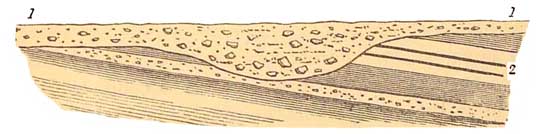
1. Boulder-clay filling a valley. 2. Coal-measures with beds of coal.
find it crop up deep underground against a mass of Boulder-clay that fills an ancient
rocky valley, of which the plain above gives no indication.
Again, if we examine the channels of other rivers in the south-east of England, we find that in
places the
1
See 'Transactions of the North of England Institute of Mining Engineers,' vo] iii. pp. 69 to 85,
especially the Map at p. 69 and the section p. 77.
[532 The Thames Valley.]
Ouse, and its tributaries in Bedfordshire, and also many other streams flow through areas
covered with this clay, and have cut themselves channels through it in such a way as to lead to
the inference that parts of the valleys in which they run did not exist before the Boulder-bed
period, but that they have excavated their courses through it and the underlying Oolitic strata,
and thus formed a new system of valleys. These often only apply to parts of their channels.
Again, with regard to the Thames, I have said that it is remarkable that it rises in the Seven
Springs, not far from the edge of the Oolitic escarpment of the Cotswold Hills that overlooks the
Severn, which runs in the valley about 1,000 feet below. The infant Thames
FIG. 106.
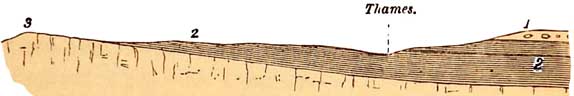
1. Boulder-clay. 2. London Clay. 3. Chalk.
thus flows at first across
a broad tableland of Oolitic rocks, and by-and-by comes to a second tableland
formed of the Chalk, and the wonder is that there its course was not turned
aside by that high escarpment. Instead of that being the case, a valley cuts
right across the escarpment of Chalk, through which the river flows, and
this I have already explained in Chapter XXX. This escarpment dates from
long before the deposition of the Boulder-beds, for we find far-transported
boulders and Boulder-clay at its base, while in the same neighbourhood the
drift has not always been deposited on its slopes, nor yet does it lie on
the top. Yet north of the mouth of the estuary of the Thames in Essex we
[River Gravels and Boulder Clay. 533]
find Glacial deposits down to the level of the sea and passing into it; and near Romford, east of
London, there are tablelands covered with Boulder-clay, which overlook he valley of the
Thames. These phenomena, taken as a whole, certainly show that all the upper valley of the
Thames is of older date than the Glacial epoch, and though Boulder-beds are found at Southend,
on the north side of the mouth of the estuary, none occurs on its southern shores, nor in the
plains and valleys of the Weald. Therefore, I now see no reason why the lower valley of the
Thames west and east of London should not be entirely pre-Glacial, in which case it may be that
some of its high-level gravel terraces belong to that date. The question is still in debate among
geo logists. I use the term high-level gravels to express the fact that thick deposits of gravel and
barns having been formed in the valley, this alluvial detritus was subsequently cut into a
succession of river-terraces in consequence of changes, slight but effective, in the physical
geography of the area, and it is obvious that the highest terrace overlooking the river must be
the oldest, and so on in succession till we reach the river-bank of to-day.
Before describing the relation of the river-gravels of the south of England to the Glacial epoch
and palmolithic implements and mammalia, it is desirable to explain some of the details of the
manner in which rivers have excavated their own valleys in solid rocks where no valleys
existed before the drainage of the country took the general direction of its present flow. On the
Continent, the Moselle and the Seine form excellent examples, and on a smaller scale many
British rivers, including the Thames, have followed the same law.
Suppose a river flowing in a sinuous channel in the
[534 River-slopes.]
direction in which the arrows point in the following diagram:—
FIG. 107.
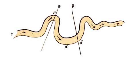
If the banks be high, they almost always have the shape shown in the section lines a and b across
two of the greater curves of the river. The water rushing on
FIG. 108, a.
is projected with great force against the concave part
of the curve, c, fig. 108, and in like manner it is
again strongly projected against the concave cliff, d,
Fm. 109, b.
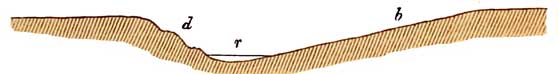
fig. 109. The result is, that the water wears back the cliffs, c and d; or, what tends to the same
end, in conjunction with the wearing action of the water, the debris, loosened by atmospheric
causes on the steep slopes, a and d, readily slips down to the level of the river, and is carried
away by the force of the stream, thus making room for further slips.
[ Cliffs. 535]
When we think of the meaning of this, it at once explains the whole history of these constantly
recurring forms, in all winding rivers that flow between rocky banks higher than broad
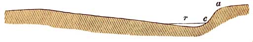
alluvial plains and deltas. Take the history of the curve, fig. 107, as an example. On a high
tableland the river, r, at an early period of its history, flowed where it is marked in fig. 110,
the beginning of the curve, c, fig. 107, having already been established, but without any high
cliffs. Then the stream, being driven with force against the concave curve, c, by degrees cut it
back, we shall suppose, to c1, at the same time deepening its channel. A
FIG. 110.
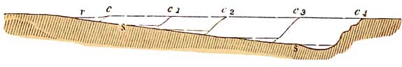
cliff was thus commenced at c1, and, as the river was changing its bed by constant encroachment
in the same direction, a gentle slope, s, began to be established, facing the cliff c1, and so, on
and on, through long ages, to c2, c3, and c4,where the present cliff stands, itself as temporary as its
smaller predecessors. This is the reason why in river curves, the concave side of the curve is
so often opposed by a high rocky bank, while the convex side so generally presents a long gentle
slope, s s, often more or less covered with alluvial detritus. In countries free of glacial debris,
these effects are often best seen in their perfect simplicity; and in this way the Moselle, and the
Seine near Rouen are, so to speak, model rivers. In many a British river it is clearly seen—on
the Wye in South Wales, in many a river and
[536 River Terraces.]
minor stream in Derbyshire, Lancashire, and Yorkshire, and on the Thames, on the banks of its
long sweeping curves where it passes through the Cretaceous escarpment between Appleford and
Wallingford. In this way rivers must act and have always acted. It was during a residence on the
banks of the Moselle in 1860 that I first learned this lesson.
On the banks of the Thames
below Maidenhead, and on those of many other rivers, there are frequent terraces,
often cut out in more ancient gravels, which it had previously deposited.
This is one of the effects of the past and present progressive action of
rivers, close to or at various distances from any river as it now exists,
according to its size and other circumstances. Sometimes these terraces have
even been cut in solid rock, but more frequently in Boulderclay, or in old
gravels. Cases such as the following are frequent. The hills or tablelands
on either side are, perhaps, made of solid rock, and the terraces lying between
the higher slopes and the rivers consist of gravel of comparatively old date.
The river at one time flowed over the top of the highest gravel terrace,
and winding about from side to side of the valley, and cutting away detritus,
it. formed the terraces one after another, the terrace on the highest level
being of oldest date, and that on the lowest level, that bounds the modern
alluvium, the latest.
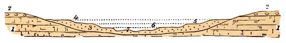
Thus, in the following figure, No. 1 represents the solid rocks of a country, covered on the top
of the tableland with Boulder-clay, No. 2, these bounding a wide valley partly filled with
ancient gravel, No. 3, which originally filled the valley from side to side as high as the
uppermost dotted line, 4; but a river flowing through, by degrees bore part of the loose detritus
[Mammalia and Flint Implements. 537]
to a lower level, thus cutting out the terraces in succession, marked Nos. 5, 6, and 7.
It often happens, that alluvial and gravelly deposits that sometimes even cap minor hills are left
marking ancient levels of rivers; and in such gravels, sands, and barns, the bones of animals of
extinct and living species have been often found, together with the pa1aolithic handiwork of
ancient races of men.
Viewed as a whole, the remains of mammalia found in these river beds, have been generally
believed to be of post-Glacial age, and in this opinion I coincide with regard to some of the
rivers. One circumstance is, however,
FIG. 111.
worthy of special remark, that to a great extent they are identical in the river gravels of the
southern half of England, with the species found in the British bonecaves, a list of which is
given at page 481.1 They consist of the White and Cave Bears, the Ermine, the Otter, Fox, Wolf,
Hyna (spelœa), Lion, the Red-deer, Reindeer, and Cervus megaceros, the Musk-sheep, Ox and
Bison, Hippopotamus (major), Pig, Horse, two species of Rhinoceros (R. leptorhinus and R.
hemitœchus), two species of Elephants (E. primigenius and E. antiquus), Hare-rat (Lagomys
spelœus), Spermophilus (a
1
The Cave Mammalia, also known in river deposits, are Rhinolophus,
ferum-equinum, Vespertilio noctula, Sorex vulgaris, Ursus Arctos, Gulo luscus,
Meles taxus, Mustela putorius, M. martes, Felix catus, F. pardii, F. lynx,
Machairodus latidens, Alces malchis, Cervus Browni, Rhinoceros leptorhinus
(?), Lepus cuniculus, Lagomys spelœus, Spermophilus erythrogenoides, Arvicola
pratensis, A. agrestis, A. amphibus, and Castor
fiber.—DAWKINS.
[538 Man and the Mammoth.]
Squirrel), Rabbits, Mice, and some other small animals. With the extinct Mammals mentioned
above, the works of man in the state of flint weapons, &c. have of late years become familiar to
English geologists. For long they shrunk from the idea with excessive caution, and the full proof
first came before them from France.
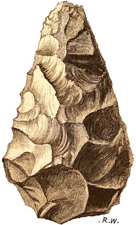
In the year 1847, a French savant, Mons. Boucher de Perthes, of Abbeville, published an
account, in the first volume of his 'Antiquités celtiques,' of flint implements, the work of man,
found in association with the teeth of the Mammoth (Elephas primigenius) in the old river
gravels of the Somme. The strata consisted of surface soil, below which were nearly five feet of
brown clay, then loam, then a little gravel containing land shells, and along with these shells
the teeth of the Mammoth. Below that level there occurred white sand and fresh-water shells,
and again the bones and teeth of the Mammoth and other extinct species; and along with these
bones and teeth, a number of well-formed flint hatchets of what we now call the palæolithic
type.
Geologists were for long asleep on this subject. M. de Perthes had printed it many years, but
none of them paid much attention to him. At length, Mr. Prestwich having his attention drawn to
the subject, began to examine the question. He visited M. de Perthes, who distinctly proved to
him, and afterwards to other English geologists, that what he had stated was incontestably the
fact. These implements are somewhat rude in form, but when I say 'rude,' I do not mean that
there is any doubt of their having been formed artificially. They are not polished and finished,
like those of later date in our own islands, or the modern ones brought from the South Sea
Islands; but there can be no doubt whatever that they were formed by
[Man and the Mammoth. 539]
the hand of man;. and I say this with authority, since, for more than thirty years, I have been
daily in the habit of handling stones, and no man who knows how chalk flints are fractured by
nature, would doubt the artificial character of these ancient tools or weapons.
The same kind of observations have been made in our own country. In the neighbourhood of
Bedford, on the Ouse, there are beds of river gravel of this kind which rise about twenty-five
feet above the level of the river, in broad terraces; and in one of these, far above the river,
there have been found a considerable number of flint hatchets, associated with river shells, the
bones of the Mammoth, old varieties of oxen, and various other mammalia. By the river
Waveney also, on the borders of Norfolk and Suffolk, at Hoxne near Diss, the same phenomena
have been observed in old gravel pits, made for the extraction of road materials; and it has been
proved that near the mouth of the estuary of the Thames, between the Reculvers and Herne Bay,
flint hatchets of Palaeolithic type have fallen from the top of a cliff of Eocene sand, which is
capped with high-level river-gravel of the ancient river. These were first found by Mr. T.
Leech (see fig. 112). Later I found one on the beach partly water-worn by the waves, and at the
same time, Prof. T. McKenny Hughes found another, fresh and unworn, and both are of
pa1olithic type. No bones have as yet been observed in that precise locality along with the
implements, but in many places further up the Thames, the remains have been found of extinct
mammalia. For example, at Acton, a few miles west of London, at a height of about twenty feet
above high-river mark, Colonel Lane Fox found Elephas primigenius, Rhinoceros hemitœchus, Hippopotamus major, Bos primigenius
[540 Palœolithic Implements and]
Bison priscus, Cervus tarandus, and other species in a middle terrace; and at a height of
seventy
FIG. 112.
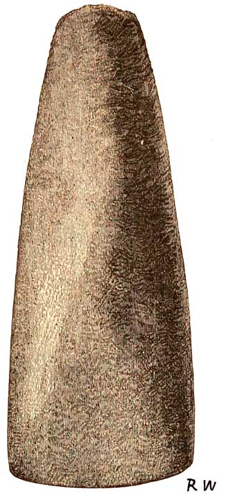
Palaeolithic flint hatchet, Herne Bay. In the Museum of Practical Geology.
feet above high-water mark, near the same village, he found a palæolithic flint implement,
besides flint flakes.
[Exinct Mammalia. 541]
They lay in a bed of ochreous sandy clay, about one foot in thickness, which reposed immediately
on the blue London Clay.
On the south side of the Thames, on the Cray, a tributary of the Darent, which enters the Thames
at Dartford Marshes, palolithic implements have been found near Green Street Green; and in
other places, in the valley of the Medway near Maidstone, and elsewhere in Kent, worked flints
have been found by Professor Hughes, Mr. Whitaker, and others.1 It is therefore very clear that
the bones of Elephas prirnigenius and other mammalia, some of them extinct, occur in many
places associated with the works of pre-historic man. As yet, however, the bones of man have
never been discovered along with extinct mammals in British river gravels, unless we get a
hint on the subject from the discovery of human skulls, fifty-three feet beneath the surface, at
the Caron tin stream-works, north of Falmouth, 'mingled with bones of deer and other animals,
among wood, moss, leaves, and nuts,' and 'at Pentuan human skulls are stated to have been found
under about forty feet of detrital accumulations, also mingled with the remains of deer, oxen,
hogs, and whales.'
2
There is, of course, plenty of evidence that some of the alluvial deposits of the Thames and many
other southern rivers are altogether post-glacial, and the history of these alluvia can often be
traced down to
1
For many details see 'Ancient Stone Implements,' by John Evans, F.R.S., chap. xxiii.
2 'Geological Report on Cornwall, Devon, and West Somerset,' 1839, P. 407: 'The Geological
Observer,' 1853, p. 449. Sir H. T. De la Beche. The accounts of these discoveries are scarcely
sufficiently definite for an opinion to be formed with respect to their comparative antiquity.
[542 Post-glacial Alluvia.]
historical times, as, for example, in the case of the alluvial meadows of the Ouse, once a
commodious estuary, in which the Saxon fleets could ride as far up as Alport, a mile above
Lewes. Further north the peats and broad marshy alluvia of the Wash lie on Boulderclay, and the
same is the case with what may be called the recent warps of the Humber and much of the loamy
alluvial strata that cover the broad plain of York and pass northward to the Tees, between the
Oolitic escarpment and the uprising of the western slopes of the Magnesian Limestone and
Carboniferous rocks. The gravels and clayey alluvia of the Wear and the Tyne play the same
part, beautiful examples of the latter being well seen on the banks of the Tyne below Newcastle,
and above that town at the junction of the North Tyne with the larger river. In great part of the
Severn valley the same kind of phenomena are apparent, and indeed in many of the river valleys
of England the occurrence of old river detritus above the Boulder-clay is not to be doubted.
These gravels and other alluvia were therefore often made by rain and the wasting action of the
rivers sometimes working on the Boulder-clays, and sometimes partly wearing out new
valleys, and when flooded spreading sediments abroad on their banks. As in the older alluvia, so
in these more recent deposits, it is natural that many bones of Mammalia should be found, a few
of which may be of extinct species. It is, however, certain, that in the subject of river-gravel
Mammalia, there has been a good deal of confusion arising from the habit of their having been
assumed to he all of the same age.
I have already stated (p. 482) that after the deposition of the Glacial deposits, Britain, by a
considerable
[The Pre-historic Rhine. 543]
elevation of the land and sea-bottom, was re-united to the Continent, chiefly by a broad plain of
Boulder-clay. Through this plain I think that the Rhine must have wandered in pre-historic
times to what is now a northern part of the North Sea, and all the eastern rivers of England—the
Thames, the rivers of the Wash and the Humber, the Tyne—and possibly some of the rivers of
Scotland, were its tributaries.
This Boulder-clay, from the manner in which it was formed had a very irregular surface,
enclosing lakes and pools, some of which may still be seen on the plains of Holderness. I have
said that after the deposition of the Boulder-clay, Britain was re-united to the Continent, but it
is well known that various oscillations of the relative level of the land to the sea took place
during the Glacial epoch, and under these circumstances it may, not improbably, have been
partly joined to the mainland during inter-Glacial episodes, or again, when glacier ice covered
broad tracts of country.
At such times the present mouths of many British rivers could have had no immediate relation
to their ancient mouths, for the places of their present mouths then lay far inland. Under such
circumstances it seems not unlikely that alluvial gravels, such as those of Bedford Level, may
have been deposited in lakes dammed up by some old Boulder-clay that formed part of the plain
through which the rivers flowed. The wide gravel plain within the circuit of the great moraine
of the Dora Baltea in Piedmont forms a sort of case in point, for, according to Gastaldi, an old
lake-hollow has there been entirely filled with gravel borne by the river from the VaT d'Aosta.
It is often difficult to account for the great thickness of these lowlying gravels on any other
hypothesis,
[544 Flint Implements.]
since in many cases they are not estuarine, for they contain no sea-shells, but only land
and freshwater species, mingled with occasional trunks of trees, and the bones of mammalia,
some of which are of extinct species.
I have previously stated that
bone-caves in Britain as caves, may have been of pre-Glacial date, and the
occurrence of worked flints along with extinct mammals in the Victoria Cave,
shows that there man is either of inter-Glacial or pre-Glacial age, for,
at the mouth of the cavern, Boulderclay lay over the sediments that contained
these remains, as proved by Mr. Tiddeman (see p. 465). In like manner I am
satisfied that Mr. Skertchly has nearly proved to demonstration the occurrence
of flint implements in brick-earth beneath the Chalky Boulder-clay of the
neighbourhood of Brandon, this brick-earth being probably of interGlacial
age, for the Chalky Boulder-clay is, in his opinion, not one of the earliest
glacial deposits. I have also shown, by the testimony of many accurate investigations,
that in the bone-caves of Somersetshire and Devonshire the works of man occur
with extinct mammals, and the same is the case in the ancient gravels of
the Thames and other rivers.
Arguing on these points, Mr. James Geikie says:
If palolithic deposits have a very limited range, such
is not the case with those of neolithic age (fig. 113).
Implements belonging to this latter age occur everywhere throughout the British Islands. From
Caithness to Cornwall, and from the east coast of England to the western borders of Ireland they
are continually being picked up. Even in the bleak Orkney and Shetland Islands, and all over the
inner and outer Hebrides, relics of neolithic times have been met with, so that the wide
[Flint Implements. 545]
distribution of these implements is in striking contrast to the limited range of pa1olithic
remains.
We know that neolithic man was accompanied by a
FIG. 113.
Neolithic hatchet in the Museum of Practical Geology.
Dredged from the bed of the Thames,
Erith.
mammalian fauna that differed very much from that with which palolithic man was associated.
Dogs,
[546 Man and the Glacial Epoch.]
horses, pigs, several breeds of oxen, the bison, the red deer, the Irish elk, and such like, were
the characteristic forms of neolithic times. . . .
How then are all these facts to be accounted for?
. . . The answer which I give
to all these queries is simply this—the palolithic deposits are of pre-Glacial
and inter-Glacial age, and do not, in any part, belong to post-Glacial times.
They are either entirely wanting, or very sparingly represented, in the midland
and northern counties, in Wales, Scotland, and Ireland, because all those
regions have again and again been subjected to the grinding action of land-ice,
and the destructive influence of the sea. But in those districts which were
not submerged during the last. great depression of the land, and in such regions
as were never overwhelmed by the confluent ice-masses, the valley gravels
form a continuous series of records from preGlacial times to the present
day . . . . To the last inter-Glacial period, then, we must refer the great
bulk of the paleolithic river-gravels of the southeast of England.'1
I go further than this, for though it cannot be proved to a demonstration that man inhabited our
area in pre-Glacial times, yet the concurrence of probabilities that he did so is so great, that I
have a profound conviction that, at that epoch, here he must have been. I have already more than
hinted at his presence in the south, inthe caves of Devonshire, while the more northern areas
were shrouded in ice (p. 462). If he inhabited the British area during inter-Glacial times, why
should he have come at that precise period and not before. It seems to me much more probable
that he did live here before the Glacial epoch began, and that he retired to
1 'Great Ice Age,' pp. 530 and 531.
[Reliquœ Aquiyanicœ. 547]
the south before the advancing glacier ice-sheets. The changing climate might by degrees suit
him well enough, for do not the Greenlanders of our own time live in comfort in their own way
among and on the edges of the snows and glaciers of Greenland. Ethnologically, Professor Boyd
Dawkins, in 'Cave Hunting,' has compared them to our own Palæolithic Man. If in Britain such
men survived the Glacial epoch, their blood, much diluted, may even be among us still.
Before quitting this part of the subject I may repeat that on the Continent, in caves on the
Meuse, Dr. Schmerling found bones of men mingled with those of the Cave Bear, Hyæna,
Elephant, and Rhinoceros.
In a magnificent work, 'Reliquæ Aquitanicæ,' by the late Messrs. Edouard Lartet and Henry
Christy, ably edited by Professor T. Rupert Jones, an account is given of the caves of Dordogne
in the south of France. These, in the valley of the river Vezère, have yielded bones of
and Felis spelœa (Lion), Ursus spelœus, Wolf and Fox, the Mammoth, Musk Sheep, Aurochs,
Chamois, Ibex, Reindeer, Red Deer, Megaceros Hibernicus, Horse, and a few others, and among
these were found numerous implements both of flint and bone. The caverns were inhabited by
man, and numbers of the bones have been broken, partly for the extraction of the marrow.
Among the bone implements are needles, harpoons, and daggers, while of stone there are
numerous flint knives, spear-heads, &c., all made by chipping, and, unlike neolithic
implements, quite unpolished. More interesting still, on the bones and horns themselves are
carved prehistoric drawings, executed with considerable skill, of the Reindeer, Horse, Ibex,
Bison, Birds, and most important of all, from the Cave of La Madelaine, in Dordogne, an
unmistakable incised drawing
[548 Man and extinct Mammalia.]
of the Mammoth with shaggy mane, executed on part of a tusk of the gigantic beast. Should
anyone still feel inclined to doubt the stratigraphical evidence that man was contemporary with
the Mammoth, he will probably feel compelled to admit the evidence yielded by this tusk.1
Further, in the surface strata of the Meuse, called Loess near Maestricht, human skeletons with
some abnormal peculiarities are said to have been found. I have seen these bones, which
certainly have an antique look, but some doubt exists as to the precise circumstances under
which they were discovered. In the same neighbourhood, however, it is certain that a human jaw
was found in strata containing the remains of Mammoths, &c. Many other examples might be
given, of the remains of old races of men in such like caverns or in river deposits; but enough
has been said to show that there can be no doubt that man was contemporary with extinct
Mammalia; and there can he little doubt that his origin in our island dates back to a time when
the country was united to the mainland, and that, along with the great hairy Mammoth, the
Rhinoceros, the Hippopotamus, Lion, Hyæna, and other mammalia partly extinct, he travelled
hither at a time when the arts were so rude, that he had no means of coming except on foot.
One word more on a kindred subject. Round great part of our coast we find terraces from twenty
to fifty feet above the level of the sea, and in some places the
1 A fine specimen of this cave bone-breccia, with a needle and flint implement, may be seen in
the Museum of Practical Geology, together with casts in plaster of some of the carved figures.
The originals, including the figure of the Elephas primigenius, belong to the British Museum.
[Sea Terraces. 549]
terrace runs with persistence for a number of miles. Round the Firth of Forth, for example, on
both shores, there is an old sea cliff of solid rock, overlooking a raised beach or terrace, now
often cultivated, and then we come to the present sea beach. This terrace usually consists of
gravel and sea-shells, of the same species with those that lie upon the present beach, where the
tide rises and falls. The same kind of terrace is found on the shores of the Firth of Clyde, and
round the Isle of Arran, and in almost all the other estuaries of Scotland, and in places round the
coast of the West Highlands. Old sea caverns are common in these elevated cliffs, made at a time
when they were daily washed by the waves. Similar or analogous raised beaches occur on the
borders of Wales, and in the south of England. In Devon and Cornwall there are the remains of
old consolidated beaches clinging to the cliffs from twenty to thirty feet above the level of the
sea. It is clear, therefore, that an elevation of the land has occurred in places to the extent of
about forty feet, at a very recent period, long after all the living species of shellfish inhabited
our shores. In Scotland other old sea terraces occur at heights of a hundred feet and more.
Further, in the alluvial plains
that border the Forth, and on the Clyde in the neighbourhood of Glasgow,
at various times, in cutting trenches, canals, and other works, the bones
of whales, seals, and porpoises, have been found, at a height of from twenty
to thirty feet above the level of high-water mark. Now it is evident that
whales did not crawl twenty or thirty feet above highwater mark to die, and
therefore they must either have died upon the spot where their skeletons were
found or been floated there after death. That part of the country, therefore,
must have been covered with
[550 Sea Terraces.]
salt water, which is now occupied simply by common alluvial detritus. But the story does not
stop there, for together with the bones of the whales in the upraised marine clays of the Forth,
implements of bone and wood have been obtained, and in beds on the Clyde, canoes were found in
a state of preservation so perfect that all their form and structure could be well made out. Some
of them were simply scooped in the trunks of large trees, but others were built of planks nailed together—square-sterned boats indeed, built of well-dressed planks—and the inference has been
drawn by my colleague, Professor Geikie, who has described them, that this last elevation took
place at a time that is possibly historical.
There is one
piece of evidence with respect to the possible recent elevation of these
terraces which I think is deserving of attention, and it is this :—In the
neighbourhood of Falkirk, on the south shore of the Firth of Forth, there
is a small stream, and several miles up that stream, beyond the influence
of the tide of the present day, there were, at the end of last century, remains
of old Roman docks, near the end of the Roman Wall, usually called the Wall
of Antoninus, that stretched across Scotland from the Firth of Clyde to the
Firth of Forth. These docks are now no longer to be seen; but so perfect
were they, that General Roy, when commencing the triangulation of Scotland
for the Ordnance Survey, was able to describe them in detail, and actually
to draw plans of them. When they were built they were of course close to
the tide, and stood on the banks of a stream called the Carron, believed
by Professor Geikie to have been tidal; but the sea does not come near to
them now. He therefore naturally inferred that when they were constructed
the relative
[Wall of Antoninus. 551]
height of the land to the sea must have been less than at present.
Again, the great Wall of Antoninus, erected as a barrier against invasions by the northern
barbarians of the territory conquered by the Romans, must have been brought down close to the
sea level at both ends. Its eastern termination is recognised by most antiquaries as having been
placed near Carriden, where the great Falkirk flats disappear along the shore. Its western
extremity, not having the favourable foundation of a steep rising ground, now stands a little way
back from the seamargin of the Clyde. When it was built it was probably carried to the point
where the chain of the Kilpatrick Hills, descending abruptly into the water, saved any further
need for fortification. But owing to a probable rise of the land, a level space of ground, twenty
or twenty-five feet above the sea, now lies between high-water mark and the base of the hills,
and runs westward from the termination of the wall for several miles as far as Dumbarton. Had
this belt of land existed then, there appears little reason to doubt that the Romans would not
have been slow to take advantage of it, so as completely to prevent the Caledonians, from
crossing the narrow parts of the river, and drive them into the opener reaches of the estuary
below Dumbarton.
While the position of marine shells in situ proves the former presence of the sea at a height of
20 or 25 feet above its present level, along both sides of the island, it is possible that in the
case both of the Clyde and Forth, the change of level within the human period may be partly due
to silting up, though it must always be extremely difficult to draw a line between the results of
the two operations.