AFTER the discovery by Dr. Mantell of the fresh-water nature of the Hastings Sands and Weald
Clay, it became customary with some geologists, led by Edward Forbes, to consider the
PURBECK BEDS as forming the topmost subdivision of the Oolites, and the Wealden strata as
belonging to the Cretaceous series; but as, in reality, the interval between the marked marine
series of the Oolitic and Lower Cretaceous epochs is, in Britain, bridged over by the terrestrial
and fluviatile episode of the Purbeck and Wealden beds, it is more convenient, and, in the chief
part of the British area, more philosophical, to treat of these formations as marking one great
local epoch.
For the stratigraphical arrangement of these strata in the Isle of Purbeck, see fig. 76, p. 347.
I here use the term Lower Cretaceous, in the sense in which it has been applied to the Atherfield
Clay and Lower Greensand ever since the days of Dr. Fitton, at the same time being well aware,
that all the Wealden strata above the Purbeck beds, and up to the top of the Lower Green sand,
are the geological equivalents in time of the marine Neocomian strata of the Continent of Europe,
though with us it happens, that the lower and middle subdivisions of these beds are represented
by fresh-water strata in the south of England.
[202 Purbeck and Wealden.]
I have now to describe a series of deposits that were formed at the mouth of a river in a large
delta, comparable in size to the largest deltas of the living world, and consisting of the following
subdivisions, the oldest being placed at the bottom:
Purbeck
and
Wealden Series.
{
Weald Clay.
Hastings Sands and Clays.
Purbeck limestone Marls and Clays.
The events that brought about the formation of these strata seem to have been as follows:
By the deposition of that series of beds of limestone and shales that constitute the Oolitic strata,
a great marine area was more or less filled with sediments, the last of which is the Portland
Limestone, Probably aided by partial upheaval of the flat-lying strata, a portion of this area
was invaded by the waters of a large continental river, the rise of land having been sufficient to
unite Britain with the Continent of what is now Europe, which, however, at that time presented
very different contours from those of the present day. We must now conceive the old islands,
which I described in the last chapter, as forming groups of hills and mountains, rising out of
vast plains, the surface of which consisted of horizontal or nearly horizontal Upper Oolitic
strata,through which, from some far-off unknown sources, a long and broad river ran. The
earliest strata of the Purbeck Beds must have been formed in open, clear, fresh water, in the
broad mouth of this river, for near Tisbury in Wiltshire, they pass gently into each other, the
marine strata of the Portland and Purbeck Limestones being firmly united in the same quarries.
The lowest beds of the Purbeck strata are of fresh-water origin, and on the whole the transition
from the uppermost marine beds of the Portland, to the lowest fresh-water strata of the
[Purbeck Beds. 203]
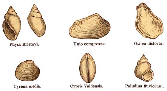
Purbeek series, is sudden. These are about 8 feet thick, and contain fresh-water remains of the
genera Cyclas, Valvata, Limnœa, Physa and Cypris.
Near the base of the Purbeek rocks, in the Isles of Portland and Purbeck (figs. 39 and 75), lie
three beds, known as the 'dirt beds,' which, from their colour and earthy character, were
clearly ancient soils. They are full of the silicified stems and stools of coniferous trees, the
former procumbent and the latter with roots attached, standing in the soil in the position in
which they grew. Plants (Cycadites microphyllus, &c.) allied to the modern Cycas and Zamia
are also found in them. In the Isle of Purbeck the whole of the Purbeck strata are about 360 feet
thick in their largest development. They consist chiefly of limestones and marls, principally of
fresh-water origin, with inter-stratifications of marine, brackish-water, and terrestrial
bands. According to the sections of the Government Geological Survey, by Bristow, there are
indications of four terrestrial surfaces, eleven sets of fresh-water beds, four brackish water,
and three marine bands, the last containing Pectens, Modiolas, Aviculas, and Thracias. One of
these, the 'cinder-bed' of the quarrymen, is about 12 feet thick, and is composed almost
exclusively of oysters (Ostrea distorta). Along with these, sparingly, was found a Perna and an
Oolitic genus of Hemicidaris, H. Purbeckensis. The fresh-water shells of the various beds are
chiefly species of Paludina, Limnœa, Planorbis, Physa, Valvata, and Unio, and Cyclas, and
along with these are several species of small fresh-water bivalve crustacea of the genus Cypris.
The celebrated Purbeck marble, so largely used in the palmy days of Gothic architecture for the
decoration of churches, lies near the top of the Upper Purbeck
[204 Purbeck Beds.]
Limestone. It is chiefly formed of remains of the
delicate fresh-water univalve, Paludina fluviorum.
Many fish have been found in the Purbeck strata;
among these, Lepidotus minor, Pliolidophorus ornatus, Microdon radiatus, Ophiopsis
breviceps, Hybodus, and Asteracanthus, are the most characteristic.
Numerous wings, elytra, and other fragments of insects (Coleoptera, Orthoptera, Hemiptera,
Neuroptera, and Diptera), occur in thin bands in the Purbeck Limestones. Some of these
(dragon-flies, &c.) are
FIG. 41.
Group of Fossils from the Purbeck and Wealden beds.
such as would live on the marshy banks of rivers.
Among the reptiles are Crocodilia—viz., Goniopholis
crassidens, and Macrorhynchus; Lacertilia; fresh-water Tortoises, and Turtles—viz, Pleurosternon concinnum, P. emarginatum, P. ovatum, &c.
In 1854, portions of the jawbone of a small marsupial insectivorous mammal, Spalacotherium tricspidens, were found by Mr. Brodie at the base of the middle Purbeck beds. At the close of
1856, Mr. Beckles commenced a further search in the same bed,
[Hastings Sand and Weald clay. 205]
which was rewarded by the discovery of about twenty species of mammals, belonging to the
genera Spalacotherium, Amblotherium, Peralistis, Achyrodon, Pterospalax, Peramus,
Stylodon, Bolodon, Triconodon, Triacanthodon, and Plagiaulax. They are altogether marsupial,
and probably this Mesozoic mammalian life was 'low, insignificant in size and power, adapted
for insect-food, for preying upon small lizards, or on the smaller and weaker members of their
own low mammalian grade' (Owen). This mammalian fauna, as far as it goes, at once suggests
comparison with the existing fauna of Australia, and the flora of the time has in part like
analogies.
Overlying the Purbeck Limestone, in the Isle of Purbeck, there are thick accumulations of
interstratified sand and clay, which belong to the geological horizon of the Hastings Sand and
Weald Clay. They are well seen on the coast cliffs of Swanage Bay, and as far as I know have
yielded no fossils excepting fragments of fossilised wood (fig. 75, p. 347).
In the Isle of Wight, strata of the same general age lie on the south-west coast, between
Cowleaze Chine and the neighbourhood of Compton Bay. In these there occur Cyrena and Cypris
and fragments of lignite, and similar strata with the same kind of fossil remains are found at the
northern end of Sandown Bay.
But the largest area of these estuarine beds now exposed at the surface in England, is that of the
Weald of Kent and Sussex, which, between the North and South Downs and the Lower Greensand,
extends from the great shingle banks of Dungeness on the east, to the neighbourhood of
Petersfield on the west, embracing an area of about 80 miles in length, by about 25 miles in
breadth where its width is greatest. For the
[206 Section at Battle.]
stratigraphical order of these strata, in this area, see diagrams, Nos. 71, 72, and 73, pp. 337-343.
In this area, near Battle, the lowest strata rise to t.he surface, being the fresh-water Purbeck
Limestone, interstratified with beds of clay. For long in this area they were known as the
Ashburnham Beds, but the fresh-water shells and other fossils found in them during the
progress of the experimental boring already mentioned, clearly proved them to belong to the
Purbeck Series. They are there about 180 feet thick, and overlie about 110 feet of shales,
somewhat sandy, with chert, which may perhaps represent the Portland beds. In the Purbeck
strata, at a depth of 130 feet, 35 feet of gypsum more or less pure were penetrated, a mineral
much more sparingly developed in the lower strata of the Isle of Purbeck, and which I consider
indicates, that these strata were not laid down in the sea, but probably in a lagoon temporarily
separated from the main current of the river. Beneath the so-called Portland beds about 921
feet of Kimeridge Clay were pierced, followed by 985 feet; of Coral Rag and Oxford Clay, when,
for want of funds, this interesting experiment was stopped at a total depth of 1,906 feet from
the surface.
The HASTINGS SANDS and WEALD CLAY are almost exclusively fresh-water beds, and must be
considered as a continuation of the deposits formed at the mouth of the great river, which
commenced with the deposition of the Purbeck limestones and shales. The name Wealden applies
to the whole group above the Purbeck rocks, and the term originated from the circumstance that
these fluviatile beds are largely developed in the Weald of Kent and Sussex. Their true character
was first discovered by Dr. Mantel. As a whole, the Hastings
[Hastings Sand and Weald Clay. 207]
sands form the lower portion, though they are largely interstratified with beds of clay, and
sometimes, by changes of character, the sands and clays of the series pass into each other. In the
various beds are found Ferns of the genera Alethopteris, Otopteris, and Sphenopteris, the
latter sometimes standing erect, as if in the position of growth. Coniferous wood and Cycadeous
plants also occur. With rare exceptions, the shells are of fresh-water genera, viz. ten species
of Unio, five species of Cyrena, besides Cyclas, Melanopsis, Melania, and Paludina, together
with Cypris, C. Valdensis, and the strata containing these are sparingly interstratified with
beds containing Ostrea, Corbula, and Mytilus. Several remarkable reptiles occur in the Weald,
of the order Dinosauria, belonging to the genera Hylœosaurus, Megalosaurus, Iguanodon,
Plesiosaurus, and Pterodactylus, together with nine species of Crocodilia, of seven genera. The
Iguanodon was first described by Dr. Mantel as an herbivorous reptile of gigantic size. Its teeth
were serrated like those of the modern Iguana, but unlike them it masticated its food. Various
fish, of the Placoid and Ganoid orders, also occur in the Wealden. The strata composing the
Hastings Sand series are about 700 feet thick.
The overlying beds of Weald Clay are of about equal thickness, and spread in a broad plain, or
series of low undulations, all round the more hilly country of the sands. They lie between these
sands and the overlying Atherfield Clay and Lower Greensand. It is in this clay that thin bands of
the well-known Sussex marble occurs, so much used in old times for monumental purposes in
churches, good examples of which may be seen in Westminster Abbey. It is formed chiefly of the
agglomerated shells of Paludina fluviorum
[208 Physical Geography.]
orum. Interstratified with the Weald Clay there are a few thin bands sparingly charged with the
remains of marine shells.
Enough has now been said to prove the fresh-water and estuarine character of the Purbeck and
Wealden beds, and also, considering the broad spread of these formations in England, that they
must have been deposited near and at the mouth of a large river. But to estimate the possible
dimensions of this Delta we must go further afield.
It has been customary to estimate
the area occupied by these deposits by measuring their length from west to
east, between the Vale of Wardour and the Boulonnais in France, and from
northwest to south-east, from Hampshire to Vassy, or in some cases taking
a shorter diameter to Beauvais, and the respective diameters given of these
lines are in the first case 320 miles and in the second 200 miles.1 Even
if these measurements were correct, which they are not, this method seems
to me to be erroneous, for the measured diameters run too much in the same
direction, whereas, as much as possible, they ought to be measured at right
angles to each other. The real measurement from west to east, between the
Vale of Wardour and the Boulonnais, is about 200 miles, and a line drawn
nearly at right angles to this, between the south side of the Isle of Wight,
where the Weald Clay occurs, and Quainton, in Buckinghamshire, where we find
the most northerly outlier of the Purbeck beds, is about 100 miles in length.
This would give an area for the Delta of about 20,000 square miles.
Rigidly to adhere to this measurement, as an accurate account of the size of the ancient Delta,
would,
1 See Lyell's 'Student's Elements of Geology,' p. 304, second edition.
[Physical Geography. 209]
however, be very erroneous. In the first place there is no reason to believe that the outliers in
Buckinghamshire, near Aylesbury and Quainton, mark the original limits of the Purbeck
strata, for the whole country has suffered so much by denudation, that we may be sure that
these beds originally spread further. Again, on the south, the Wealden strata of the Isle of Wight
are thick, and dip northerly between Cowleaze Chine and Compton Bay, and originally must have
spread to some unknown distance beyond the coast cliffs, and, indeed, we may be sure that they
now occupy part of the bottom of the sea beyond the coast line. Crossing the Straits of Dover to
the Bas Boulonnais, we find the Weald Clay much attenuated, but passing under the Cretaceous
strata for some unknown distance. Taking all these points into account it would probably not be
too much to add one-half to the 20,000 square miles, as being nearer the original area of the
Delta, or 30,000 square miles in all. The area of the Delta of the united great rivers of the
Ganges and Brahmaputra, from the sea to the latitude of Rajmahal, is usually estimated at about
40,000 square miles, and therefore it would probably be under the mark to estimate the size of
our old river as being quite as large as the largest of these great rivers of India. At the very
least it must have been as extensive as the Delta of the Quorra in Africa, the area of which has
been estimated at 25,000 square miles.
Facts such as these are sufficient to prove that this ancient stream was in its day, a first class
continental river. Away to the west of a great plain, through which it flowed, lay the granite
hills of Devonshire, separated by a broad flat valley from what are now the mountains of Wales.
The old Mendip Hills, which, as
[210 Physical Geography.]
hills, were much older than the Oolitic series, then lay buried deep beneath the uppermost
Oolitic strata, and all the ground between Wales and the high tracts of the North of England
formed part of the vast plain that bordered the river; while far away, on the north, rose the
majestic mountains which we now call the Highlands of Scotland, then much higher than now,
for ever since that time they have been undergoing waste and degradation. We have probably no
actual knowledge of the mountain vegetation of the period, but on the flats by the river there
were Equisetums in the marshes, and ferns, coniferous trees, Zamias, and Cycas on the drier
ground; crocodiles, turtles, and fish, swarmed in the waters; small marsupial mammals lived
upon the flats, along with great reptiles, the Iguanodon, Hylœosaurus, and the gigantic
Megalosaurus, while the winged Pterodactyle preyed on the insects that flitted through the air of
a climate, probably as warm as that of the Delta of the Ganges.
How far to the west this old flat land spread no man can tell, but I have no doubt that Wales stood
in the midst of it, for the Oolites passed out on the south through the area of what is now Bristol
Channel, and on the north across the country now occupied by the estuaries of the Mersey and
the Dee, and it is also very likely that at that period the whole of Ireland may have formed part
of that old land. On the east our territory was undoubtedly joined to a great continent, which,
after undergoing many revolutions, is now modern Europe, but it is hard to discover the details
of its physical geography. Of this, however, we are sure, that the Scandinavian mountains were
then loftier than at present, for they are certainly of older date than the deposition of the Old
Red Sandstone, and probably older than the Upper
[Physical Geography. 211]
Silurian series, and have suffered degradation ever since; that the chain of the Ural was in
existence, for it is of older date than the Permian strata; that the mountains of the Schwarzwald
then rose high into the air, for they are older than the New Red Sandstone; but the Alps, the
Pyrenees, and some other mountain chains, if they existed at all, were in the rudimentary stage
of comparatively low lands, feebly indicated by the occasional occurrence of fresh-water beds
amid the Oolitic and Purbeck strata, and by such phenomena as the occurrence of Pterodactyles,
and the long-tailed Archœopteryx macrura,1 in the Solenhofen state of Bavaria.
That a broad low-lying land existed at that time, amid which rose groups and ranges of
mountains in what is now Europe, there is no reason to doubt, and how that phase of physical
geography came to an end will form part of the subject of next chapter.