THE


SCENERY OF SCOTLAND


VIEWED IN CONNECTION WITH ITS

PHYSICAL GEOLOGY


BY


ARCHIBALD GEIKIE, LL.D., F.R.S.,

DIRECTOR-GENERAL OF THE GEOLOGICAL SURVEYS OF THE
UNITED KINGDOM;
FORMERLY MURCHISON PROFESSOR OF GEOLOGY AND MINERALOGY IN
THE UNIVERSITY OF EDINBURGH, AND DIRECTOR OF
THE GEOLOGICAL SURVEY OF SCOTLAND


SECOND EDITION
WITH TWO GEOLOGICAL MAPS AND NUMEROUS ILLUSTRATIONS


LONDON

MACMILLAN AND CO.

1887

481 + 21 pages, illustrated with 85 figures.


This electronic edition prepared by Dr. David C. Bossard
from a volume in his personal library.

February, 2006.

Copyright © 2006 by Dr. David C. Bossard.  All rights reserved


To roam at large among unpeopled glens
And mountainous retirements, only trod
By devious footsteps; regions consecrate
To oldest time! and while the mists
Flying, and rainy vapours, call out shapes
And phantoms from the crags and solid earth;
.... and while the streams
Descending from the region of the clouds,
And starting from the hollows of the earth
More multitudinous every moment, rend
Their way before them -- what a joy to roam
An equal among the mightiest energies!

WORDSWORTH, Excursion, b. iv.


GEOLOGICAL MAP OF SCOTLAND
click on a portion of the map to view a section at 100 ppi.
top lefttop midtop right
mid leftmid midmid right
bot leftbot midbot right

higher resolution maps

MAP OF THE GLACIATION OF SCOTLAND
click on the image to view at 100 ppi.
Glaciation of Scotland
map at 200 ppi (620 Kb)
map at 400 ppi (1.5 Mb)


CONTENTS.


PREFACE TO SECOND EDITION  v.   v  vi  vii  viii  ix

PREFACE TO THE FIRST EDITION  x. to xii.   x  xi  xii


PART I. LAND-SCULPTURE IN GENERAL


CHAPTER I  INTRODUCTORY 1   001  002  003  004  005  006  007  008  009  010  011  012  013

CHAPTER II  NATURE'S SCULPTURE-TOOLS-AIR, RAIN, RIVERS; SPRINGS, FROST 14   014  015  016  017  018  019  020  021  022  023  024  025  026  027  028  029  030  031  032  033  034  035  036  037  038  039  040

CHAPTER III  THE SEA AND ITS WORK ON THE SCOTTISH COAST-LINE  41   041  042  043  044  045  046  047  048  049  050  051  052  053  054  055  056  057  058  059  060  061  062  063  064  065  066  067  068  069  070  071  072  073  074  075  076  077  078  079

CHAPTER IV  GLACIERS AND ICEBERGS  81   081  082  083  084  085  086  087  088  089

CHAPTER V THE HISTORY OF A LAND-SURFACE  90   090  091  092  093  094  095  096  097  098  099  100  101


PART II.  THE HIGHLANDS


CHAPTER VI  PHYSICAL FEATURES AND GEOLOGICAL STRUCTURE  103   103  104  105  106  107  108  109  110  111  112  113  114  115  116  117  118  119  120  121  122  123  124  125  126  127

CHAPTER VII  THE TABLE-LAND OF THE HIGHLANDS  128   128  129  130  131  132  133  134  135  136  137  138  139  140  141  142  143  144  145  146  147  148  149  150  151  152  153  154

CHAPTER VIII  THE HIGHLAND VALLEYS  155   155  156  157  158  159  160  161  162  163  164  165  166  167  168  169  170  171  172  173  174  175  176  177  178  179  180  181  182  183  184  185  186  187  188  189  190  191

CHAPTER IX  THE HIGHLAND HILLS  192   192  193  194  195  196  197  198  199  200  201  202  203  204  205  206  207  208  209  210  211  212  213  214  215  216  217  218  219  220  221  222  223  224  225

CHAPTER X  THE HIGHLAND LAKES  226   226  227  228  229  230  231  232  233  234  235  236  237  238  239  240  241

CHAPTER XI  THE ANCIENT ICE-SHEETS AND GLACIERS OF THE HIGH-LANDS  242   242  243  244  245  246  247  248 249  250  251  252  253  254  255  256  257  258  259  260  261  262  263  264  265  266  267  268  269  270  271  272  273  274  275  276  277  278  279  280

MAP OF THE GLACIATION OF SCOTLAND (100 ppi)  facing page 248.
map at 200 ppi (620 kb.)   map at 400 ppi (1.5 Mb)


PART III  THE SOUTHERN UPLANDS


CHAPTER XII  PHYSICAL FEATURES AND GEOLOGICAL STRUCTURE  281   281  282  283  284  285  286  287  288  289  290  291  292  293  294  295  296  297

CHAPTER XIII  THE SOUTHERN TABLE-LAND AND ITS VALLEYS  298   298  299  300  301  302  303  304  305  306  307  308  309  310  311

CHAPTER XIV  THE ANCIENT GLACIERS OF THE SOUTHERN UPLANDS  312   312  313  314  315  316  317  318  319  320  321  322  323  324


PART IV  THE MIDLAND VALLEY

CHAPTER XV  PHYSICAL FEATURES AND GEOLOGICAL STRUCTURE  325   325  326  327  328  329  330  331  332  333  334  335  336  337  338

CHAPTER XVI  DENUDATION OF THE LOWLANDS  339   339  340  341  342  343  344  345  346  347  348  349  350  351  352  353  354  355  356  357  358  359

CHAPTER XVII  THE GLACIATION OF THE LOWLANDS  360   360  361  362  363  364  365  366  367  368  369  370  371  372  373  374  375  376  377  378

CHAPTER XVIII  THE LATEST MODIFICATIONS OF SCOTTISH SCENERY  379   379  380  381  382  383  384  385  386  387  388  389  390  391  392  393  394  395

CHAPTER XIX  INFLUENCE OF THE PHYSICAL FEATURES OF SCOTLAND UPON THE PEOPLE  396   396  397  398  399  400  401  402  403  404  405  406  407  408  409  410  411  412

CHAPTER XX  RECAPITULATION AND CONCLUSION 413   413  414  415  416  417  418  419  420


APPENDIX 

ITINERARY IN SCOTLAND  421   421  422  423  424  425  426  427  428  429  430  431  432  433  434  435  436  437  438  439  440  441  442  443  444  445  446  447  448  449  450  451  452  453  454  455  456  457  458  459  460  461  462  463  464  465  466  467  468  469  470  471  472

INDEX  473 - 481   473  474  475  476  477  478  479  480  481


LIST OF ILLUSTRATIONS.

NOTE: High Resolution images of all illustrations are available here.


Fig. 1.  Granite Weathering along its joints near the top of Ben-na-Chie, Aberdeenshire  17
Fig. 2.  Spheroidal Weathering of Dolerite, North Queensferry  19
Fig. 3.  Rain-eroded Pillars of Old Red Conglomerate and Boulder-Clay, Fochabers  20
Fig. 4.  Sand-dunes near Durness  22
Fig. 5.  Gullies and Ravines at the head of Glenkip Burn, Leadhills  26
Fig. 6.  Chemical action of a stream on limestone, Durness, Sutherland  31
Fig. 7.  Flagstone Cliffs, Holburn Head, Caithness  43
Fig. 8.  Flagstone Cliffs, Brough of Birsa, Orkney  44
Fig. 9.  View of the Buller of Buchan from the land side  46
Fig. 10.  Part of the Sea-Cliffs of Berwickshire-Curved Silurian Rocks  49
Fig. 11.  Brig o' Trams, Wick  63
Fig. 12.  Stacks of Duncansby, Caithness. Old Red Sandstone  65
Fig 13.  The Old Man of Hoy, Orkney 66
Fig. 14.  Noss Head, Shetland 69
Fig. 15.  Cliffs of Archean Gneiss, with pink pegmatite veins, Cape Wrath  73
Fig. 16.  Macleod's Maidens and the basalt cliffs of the west of Skye  75
Fig. 17.  Inclined Silurian strata near Girvan  78
Fig. 18.  View of the Glaciers at the head of the Nus Fjord, Northern Norway  84
Fig. 19.  View of the Highland Table-land from above Gourock, on the Clyde  104
Fig. 20.  Ben Leagach, Glen Torridon  115
Fig. 21.  Ordinary Unaltered Red Sandstone (Cambrian), Keeshorn, Ross-shire (magnified)  119
Fig. 22.  Sheared Red Sandstone forming flow a Micaceous Schist, Keeshorn, Ross-shire  119
Fig. 23.  View of. the Highland Table -land from above Dalwhinnie, looking westward  131
Fig. 24.  View of the highest group of the Grampians from the south  133
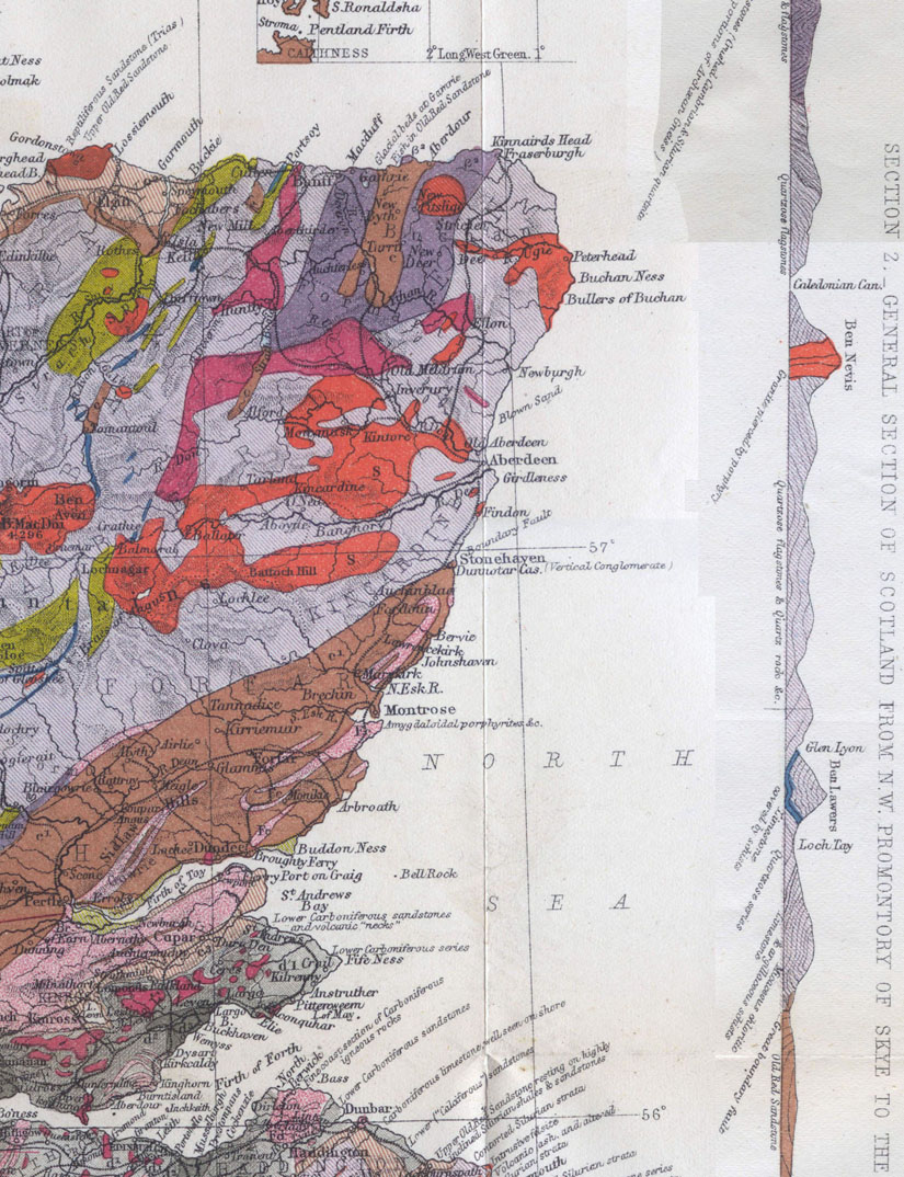
Fig. 25.  Section of the Grampian Range from Inverness to Kirriemuir  134
Fig. 26.  Diagrammatic section-of Ben Lawers  135
Fig. 27.  Section of Morven, Caithness   139
Fig. 28.  View of Ben Griam, Sutherland  140
Fig. 29.  Craig Beinn-nan-Eun, east of Uarn Var (Uarnh Mhbr, Big Cave)  142
Fig. 30.  Section across the boundary fault of the Highlands at Glen Turri, Perthshire  143
Fig. 31.  View of Ben More, Mull, from the south side of Loch Scriden  145
Fig. 32.  MacleOd's Tables, Skye  146
Fig. 33.  Ben ladain, Morven  147
Fig. 34.  Section across Loch Scriden, Mull  148
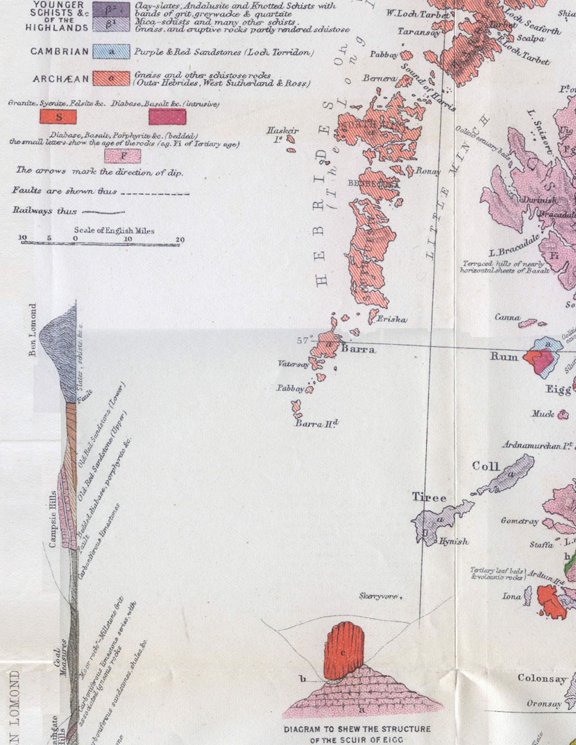
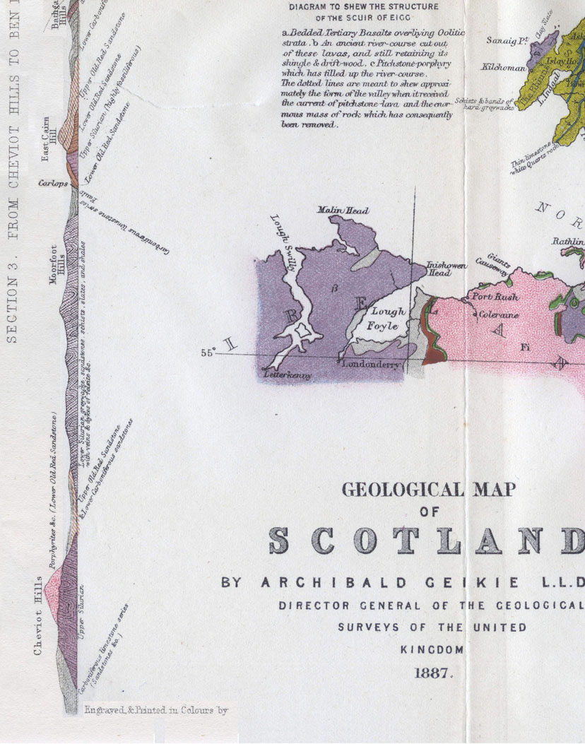
Fig. 35.  View of the Scuir of Eigg from the east  150
Fig. 36.  Section of west end of Scuir of Eigg  151
Fig. 37.  Corry on northern front of Lochnagar  165
Fig. 38.  The Black Rock of Novar, Cromarty Firth  175
Fig. 39.  Gorge of the Ericht, above Blairgowrie  177
Fig. 40.  View from the Ridge of Suidhe Fhearghas (Fergus Seat), Arran  180
Fig. 41.  Head of Loch Duich  183
Fig. 42.  View across the West Highland Plateau from the top of Ben ladain, Morven  197
Fig. 43.  View of the Cambrian Mountains of Sutherland and Ross  203
Fig. 44.  An Tealiach, Durrclonakl, Ross-shire  206
Fig. 45.  Outline of Shiehallien  207
Fig. 46.  BUChaille-EtiVe (the Herdsman of Etive), from the east  212
Fig. 47.  View of a portion of the basalt plateau, [sic o Eigg  217
Fig. 48.  View of the south side of Staffa  219
Fig. 49.  Section showing the structure of the basins of the Lakes of the Plains  227
Fig. 50.  Section showing the structure of a Moraine Lake  228
Fig. 51.  Section showing the structure of a Rock-Tam  229
Fig. 52.  Part of the Island of Lewis  239
Fig. 53.  Section across Loch Morar  240
Fig. 54.  Ice-worn rocks, Rispond, Sutherland  243
Fig. 55.  Ice-worn rocks near summit of Barone Hill, Bute  247
Fig. 56.  Ice-worn Knolls and Perched Blocks, Loch Torridon  258
Fig. 57.  Perched Blocks on ice-worn hummocks of gneiss between Loch Laxfórd and Richonich, Sutherland  259
Fig. 58.  View from the lower end of Loch Treig looking across Glen Spean  264
Fig. 59.  View of the Parallel Roads of Glen Roy from the Gap  266
Fig. 60.  Terraces at Auchnasheen  269
Fig. 61.  Moraines, Glen Cloy, Arran  275
Fig. 62.  Ice-worn islets in Loch Fyne  277
Fig. 63.  Curved Silurian Strata, coast of Berwickshire  283
Fig. 64.  Curved and Cleaved Silurian Rocks, Wigtownshire  284
Fig. 65.  Section across the Sanquhar Coal-field  285
Fig. 66.  The Manor Water, seen from the top of Cademuir, south of Peebles  290
Fig. 67.  Outline of the Southern Uplands, seen from above the Village of Barr in Southern Ayrshire  292
Fig. 68.  Tertiary dyke crossing the Glengap Burn, near Moffat 310
Fig. 69.  The Baron's Stone of Killochan  315
Fig. 70.  Sectional view of Loch Skene, Dumfriesshire  317
Fig. 71.  Loch Skene, Dumfriesshire  319
Fig. 72.  Map of Tertiary Dykes near Muirkirk, Ayrshire  331
Fig. 73.  Dykes traversing jointed volcanic tuff, Shore, Elie, Fife  332
Fig. 74.  Largo Law, Fife  334
Fig. 75.  Section across the Clackrnannan Coal-field  335
Fig. 76.  Section to illustrate the denudaf:ion of the Pentland Hills  341
Fig. 77.  View of the Firth of Tay from Moncrieffe Hill  342
Fig. 78.  Section across the Firth of Tay  343
Fig. 79.  Cora Linn, Falls of Clyde  350
Fig. 80.  Section of Volcanic Neck  354
Fig. 81.  The Bass Rock, from the south  355
Fig. 82.  Section of the form of hill in the Lowlands of Scotland, known as 'Crag and Tail'  357
Fig. 83.  Section of Boulder-Clay, Craiglockhart Hill, Edinburgh 363
Fig. 84.  Striated Stone from Boulder-Clay of North Medwin Water, Lanarkshire  364
Fig. 85.  Section of Sand and Gravel Ridges (Kames) at Carstairs, Lanarkshire  372